Changelog for STDM Version 1.1 (July 2015)
The emphasis of this release has been very much on stabilizing the platform and improving the feature set – we have added many new features, tweaked and enhanced the user experience making STDM easier to use than ever before. Data management and document generation tools have had a lot of work done to simplify: the design of tables, data access and creation of rich cartographic outputs. Whenever new features are added to software, they introduce the possibility of new bugs – if you encounter any problem with this release, please report it on STDM’s issue tracker so that the developers can check and fix it. To get technical support, please use the online resources listed below to get in touch with the pool of STDM users and developers:- For more information, please subscribe to: lists.osgeo.org/cgi-bin/mailman/listinfo/stdm-user
- To receive important news and updates around STDM in general, subscribe to: lists.osgeo.org/cgi-bin/mailman/listinfo/stdm-announce
- To browse the source codes or extend the core platform, access the repository through this link: https://github.com/gltn/stdm
- Installation
- Enhanced Custom Build for Windows
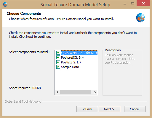
The latest build of the STDM installer includes the latest versions of the dependent software components i.e. PostgreSQL 9.4, PostGIS 2.1.7 and QGIS 2.8.2. In addition, the installer is now available in 32 and 64 bit versions depending on the architecture of the target PC.
There is also the option of installing sample data, which can subsequently be used to guide users through the software using examples contained in the user guide. The sample data includes SQL scripts for inserting sample data into the STDM database as well as shapefiles, CSV files and satellite image which are copied into the local user directory. - Installing through GLTN Plugin Repository
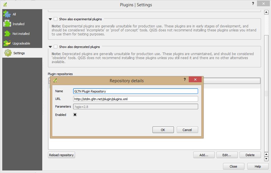
For users with an already existing installation of QGIS, they can now download the STDM plugin by connecting QGIS’ plugin manager to the GLTN Plugin repository available through this link: http://stdm.gltn.net/plugin/plugins.xml.
- Enhanced Custom Build for Windows
- Management of Spatial Units
- Introduction of Spatial Unit Manager
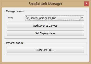
Spatial units can now be accessed through a dockable ‘Spatial Unit Manager’ window. The window provides an option for listing all spatial units in the STDM database and adding them to the map canvas for visualization. The user can also set a display-friendly name for the layer which is applied in the legend each time the layer is loaded. - Importing Spatial Units from GPX Files
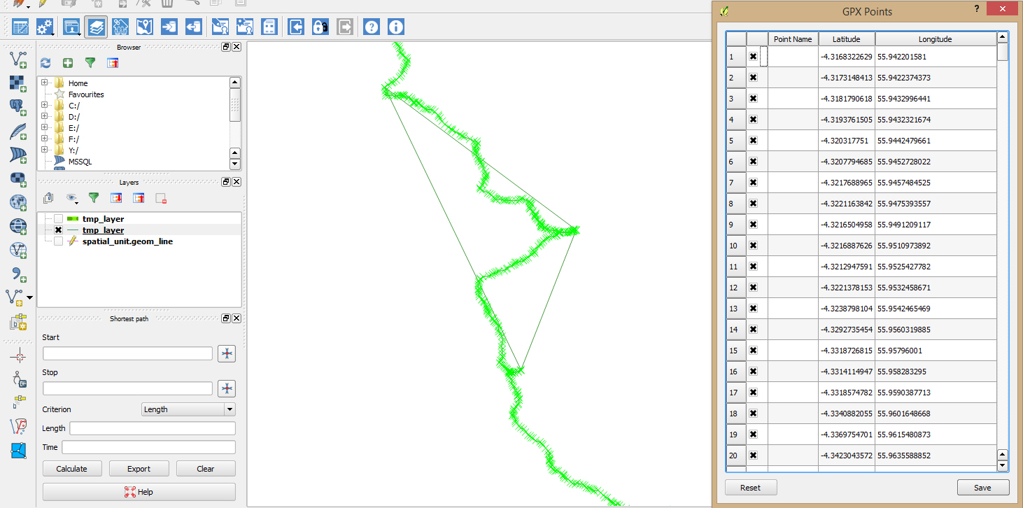
Geometry data for spatial units collected from the field and downloaded from GPS devices in GPX format can now be easily imported into the STDM database by loading a GPX file into the map canvas then selecting and editing the location of the individual points that constitute the geometry. Geometry construction from the collection of points is based on the type of the active spatial unit layer in the current edit session.
Note: Each GPX file must correspond to a single spatial unit for this to work.
- Introduction of Spatial Unit Manager
- Document Outputs
- Added Composer Items in the Document Designer
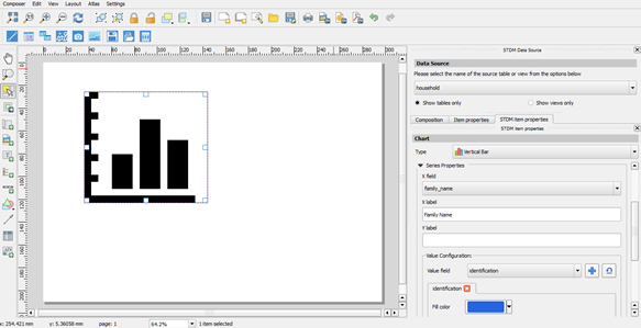
The document designer has been updated to include support for linked attribute tables (for example, showing the members of a selected household entity); linked spatial units (which enables point and line spatial units to be drawn in the output document); charts and supporting documents (of image format).
Note: Only vertical bar graphs are supported for now; more chart types will be added in the next release major release. - Advanced Filtering in the Document Generator
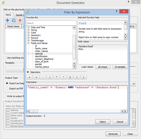
Entities can now be selected by using filter expressions through an expression dialog that enables users to specify SQL-like statements to filter items.
- Added Composer Items in the Document Designer
- Designing Data Forms
The data forms design module has been greatly enhanced that screenshots only will not do it justice.
- The module has been stabilized and provides more friendly messages during the design process.
- When specifying the columns of a table, users have the options of specifying which fields will be searchable. The list of searchable columns is applied across multiple dialogs such as entity browsers and the module for viewing social tenure relationships.
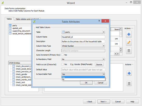
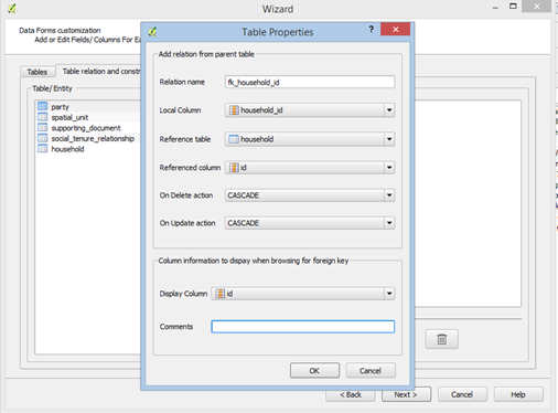
- The module provides the option of defining relationships between tables by specifying foreign keys. The result is that users can browse through related entities when adding or editing a record that is explicitly linked to another table. For example, when adding information for a person, a user can browse and select the corresponding household record if the person table contains a foreign key column referring to the household primary key.
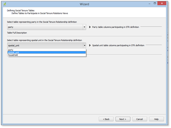
- Depending on the profile, users have the option of explicitly specifying which entities will participate in the social tenure relationship i.e. which tables correspond to party and spatial unit respectively.
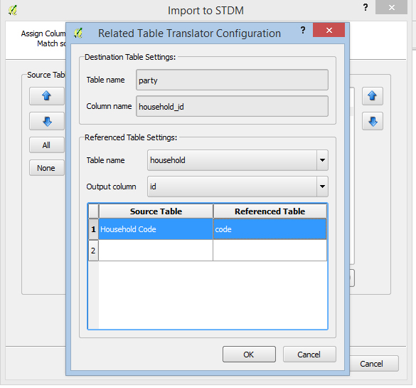
- Importing Data to Foreign Key Columns
Users can now import data to a foreign key column in the destination table using the ‘Value Translation’ framework; one implementation of this framework is the related table translator.
In order to implement this translator, the source table must contain at least one column that refers to a unique value in a related table such as household code/number that a person belongs to. During the translation process, the system will attempt to look up this value and extract a corresponding value (ideally, the value of the foreign key column) and use this value in the primary reference table.
The ‘Value Translation’ framework opens up infinite possibilities of transforming data during the importation process such as calculations of age from date of birth; importing multiple enumeration values separated in the source table say by an asterisk or semicolon etc. Look out for sample code snippets on how to adopt the translation framework in the upcoming blog in the STDM website.
- Miscellaneous
In addition a wide range of improvements have been made:
- Upon successful login, the system now checks if the specified STDM database has the PostGIS extension installed and notifies the user accordingly if the extension is not detected. This addresses some issues that previously arose if the user did not have a spatially enabled STDM database.
- The document generator module enables users to generate documents using records from the data source defined in the template. This is applicable in cases where aggregate data (from database views) computed using for example, settlement statistics derived from neighbourhood data, is used.
- Icons for accessing the modules through the menu and toolbar have been reworked to have a consistent look-and-feel.
- The module for viewing social tenure relationships has been updated to take advantage of multithreading when fetching lookup values for keyword searches.