Change Log for STDM 1.5
STDM 1.5 is a full release which includes enhanced functionality and stability improvements. The changes include the ability to save configuration as draft; copying an existing data profile; additional customization options pertaining to social tenure relationship; simpler importation of lookup values; direct switching of data profiles; identity tool for accessing the main information pertaining to a spatial unit (such as tenure status and related parties) and user interface enhancements in the GPS import tool.Database Configuration
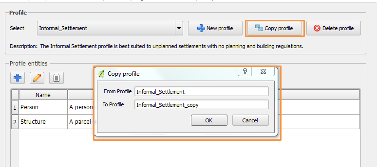
Copy Data Profile from Existing One
This time saving Database Configuration feature allows you to make a copy of an existing profile as shown in the image below. If you identify a profile in your configuration that you would like to use as a template, now you can replicate it, rename it, edit and use it without designing a new configuration from scratch. This feature greatly saves on time and increases productivity.
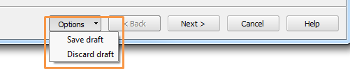
Save Configuration as Draft
This feature provides the ability to save the current customization as a draft as shown in the image below. If one is configuring a complex profile that might take hours or days to finish, it is now possible to progressively save the customization as a draft until completion. The draft copy will be loaded automatically next time the Database Configuration Wizard is loaded.
Enhanced Input Validation
The text input boxes for defining the profile name, entity name, column name, lookup name, and lookup Value name attempt to automatically update the entered text such as space and uppercase letters. The validation shows an error message when typing invalid characters as shown in the image below.
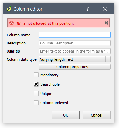
Users can also copy paste characters with space and capital letters in the text boxes.
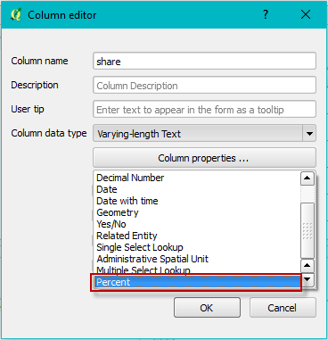
Percent Column Type
This is a decimal data type with a minimum of 0 and maximum of 100. The image below shows the Percent column in Column data type drop down menu.
The input widget in the entity editor corresponds to a spin box with a ‘%’ suffix appended to the value as shown in the image below.
![]() Auto Generated Code Column Type
Auto Generated Code Column Type
Auto Generated Code Column Type
This column type can be used to create unique codes such as parcel number, house number, etc. The column type can be found in the Column data type drop down menu as shown below.
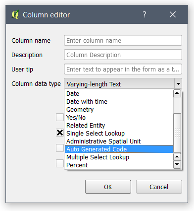
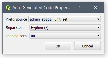
One can set the column properties such as the source table of the code prefix, code separator and leading zero as shown in the Column Property below.
The column type generates unique codes automatically based on the selected prefix source as shown in the image below.
![]()
Decimal Number Column Type
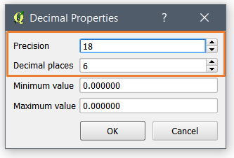
The decimal column type is enhanced with the ability to change the number of decimal places and the precision as highlighted in the image below.
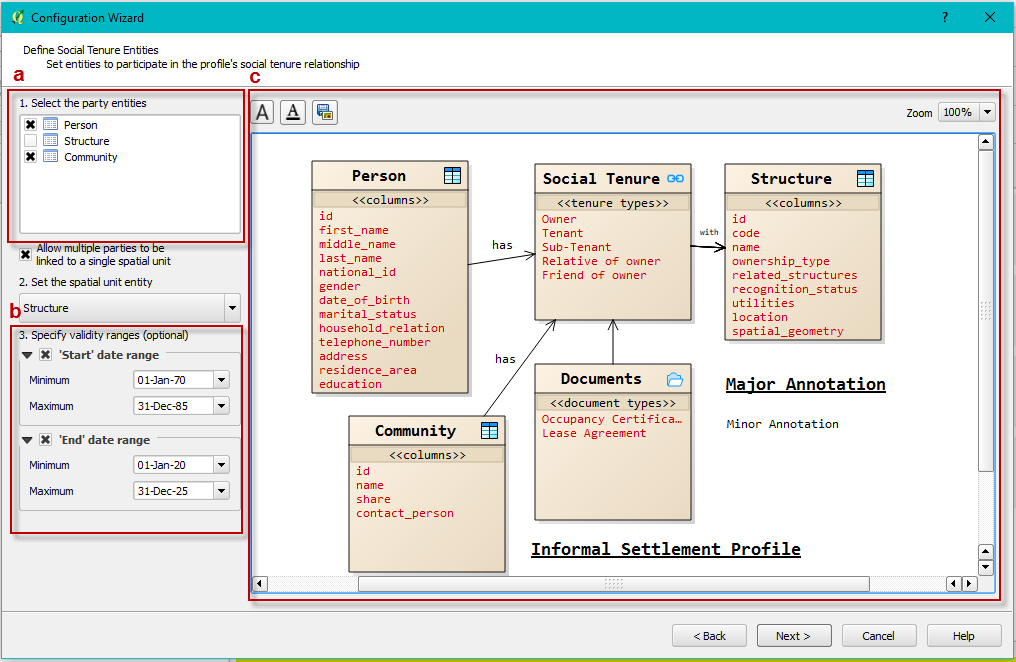
Multi Party Entity Types in Social Tenure Relationship
A profile’s social tenure relationship can now incorporate one or more party entity types; this is applicable in contexts where the tenure relationship of spatial units is shared by different party entity types such as person or community entities. See the red-colored box labelled ‘a’ in the image below.
Date Validity Ranges in Social Tenure Relationship
The respective ranges for start and end dates can optionally be specified when configuring a profile’s social tenure relationship. This ensures that the date ranges for new social tenure relationships are validated within these set limits. See the red-colored box labelled ‘b’ in the image below.
Visual Representation of Social Tenure Relationship
The basic data model of a profile’s social tenure relationship can now be visualized in the configuration wizard as shown in the image below. The model can be annotated with user-defined text and exported as an image file. This is useful in helping to visualize the linkage between the social tenure relationship entities as well as using the image files in reports, presentations etc. See the red-colored box labelled ‘c’ in the image below.
Social Tenure Relationship Views
An additional Social Tenure Relationship database view is now created upon configuring a new data profile. This view uses the spatial unit id as its id column. This makes it easy to design and generate documents for profiles that may have a party linked to more than one spatial unit. Consequently, two default database views are created:
- Spatial Unit View contains Spatial Unit records linked to Party records through the Social Tenure Relationship. The view and layer name is denoted by [spatial_unit_table_name]_vw_social_tenure_relationship
- Party Views (one or more) contain Party records linked to Spatial Unit records and social tenure information. The view is denoted by [party_table_name]_vw_social_tenure_relationship
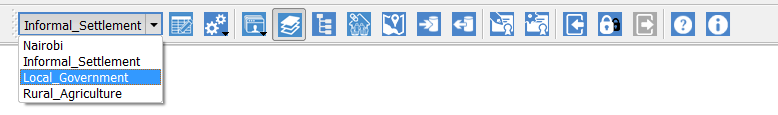
Current Profile Selection
The process of setting the current data profile has been significantly simplified with the addition of a profile selection combobox in the STDM toolbar as shown in the image below.
Social Tenure Relationship
Social Tenure Relationship (STR) Editor
The Social Tenure Relationship Editor has been completely revamped by utilizing a tree structure and a single page design that makes creating an STR record very quick and easy thereby reducing time in repetitive STR creation workflows.
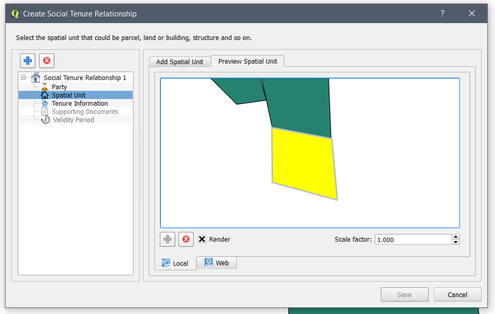
Local Spatial Unit Preview
A local map preview has been added on the existing web preview of spatial units as shown in the image below.
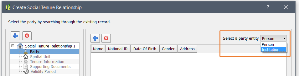
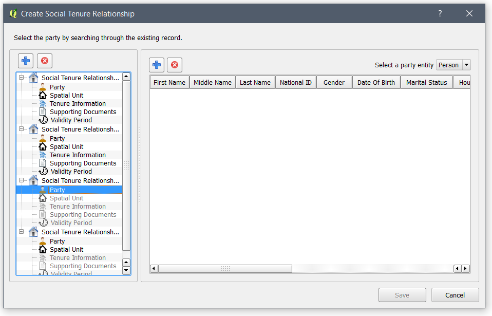
Multiple Party Entity
Users can choose more than one party entity to be linked to a spatial unit as shown in the image below. The party entities must be selected in the Configuration Wizard.
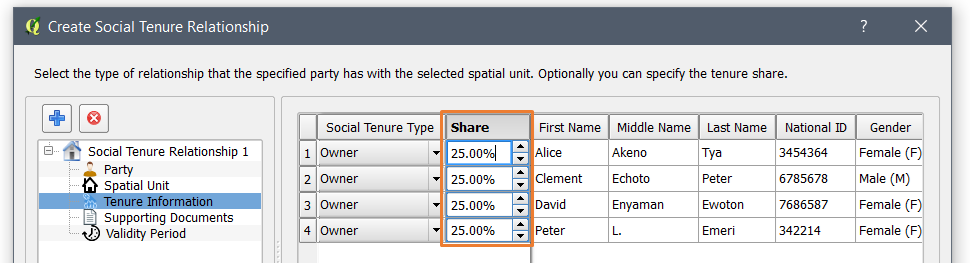
Tenure Share
The Tenure Share option has been added in the Tenure Information section. This feature enables the user to specify the tenure share for the spatial unit as a percentage. The module automatically updates the other party records’ tenure share when the share of one party record is manually changed by the user.
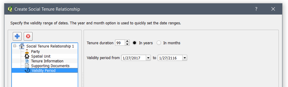
Tenure Validity Period
Users can specify the tenure validity period by choosing the start and end dates of the tenure agreement as illustrated in the image below. The tenure duration box enables the user to specify the date ranges by entering number of year or months, this is used to automatically compute the end validity date.
Multiple STR entry
Users can add multiple social tenure relationship records without re-opening the editor as illustrated in the image below.
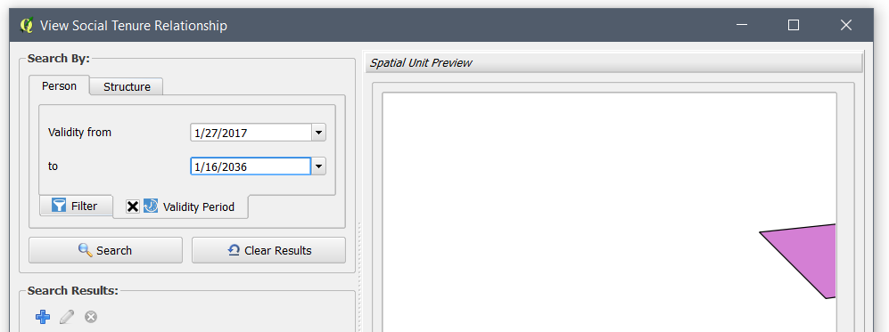
View Social Tenure Relationship
Searching of STR records is possible using tenure validity period as shown in the image below. The filter can also be disabled using the checkbox in the Validity Period tab.
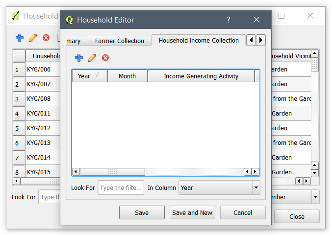
Entity Editor
A Subform inside the Primary form of STDM is added to enable the user enter records on a different entity that depends on the Primary Entity. It also enables the user to edit and delete records from within the Subform. For instance, within a Household Entity Editor, you can add a record of Household Income Entity as shown in the image below.
Data Import
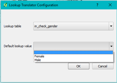
Importing Lookup Values
A lookup value translator has been incorporated to enable easier importation of lookup values as shown in the image below. Previously, one would need to use the related table translator. Using this new option, the only requirement is to specify the matching lookup table in the STDM database and configuration. A user can also specify a default value (from the selected lookup table) which will be used in case the value from the source table is not found.
Spatial Unit Manager
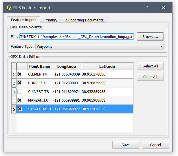
GPS Feature Import Tool
The GPS Feature Import has been completely redesigned into a single window where GPX file source and coordinate points selection is in one tab and attribute-related tabs such as Primary, Supporting Documents, and Collections tab are in separate tabs as shown in the image below.
In addition, the tool enables users to rearrange point positions using drag-and-drop. To make it clear to the user on the impact of the changes, the selection and removal of a point automatically updates the preview map. Moreover, when selecting a row, a user can view which point they have selected as it is also highlighted in the preview layer. A user can also edit the values of each coordinate pair by double-clicking the Longitude and Latitude fields.
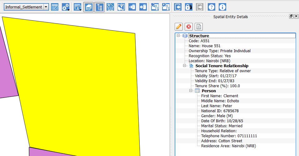
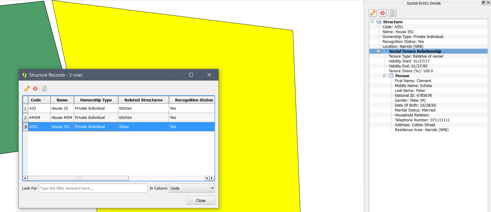
Spatial Entity Details
The Spatial Entity Details is a new module that provides a hierarchical view of Spatial Entities and Views by selecting one or more features in the map canvas as shown in the image below. If the vector layer is a Spatial Unit, it also displays the social tenure relationship information similar to the View Social Tenure Relationship module. Editing, deleting and the viewing of supporting documents is possible for relevant entities.
Spatial Entity Browser
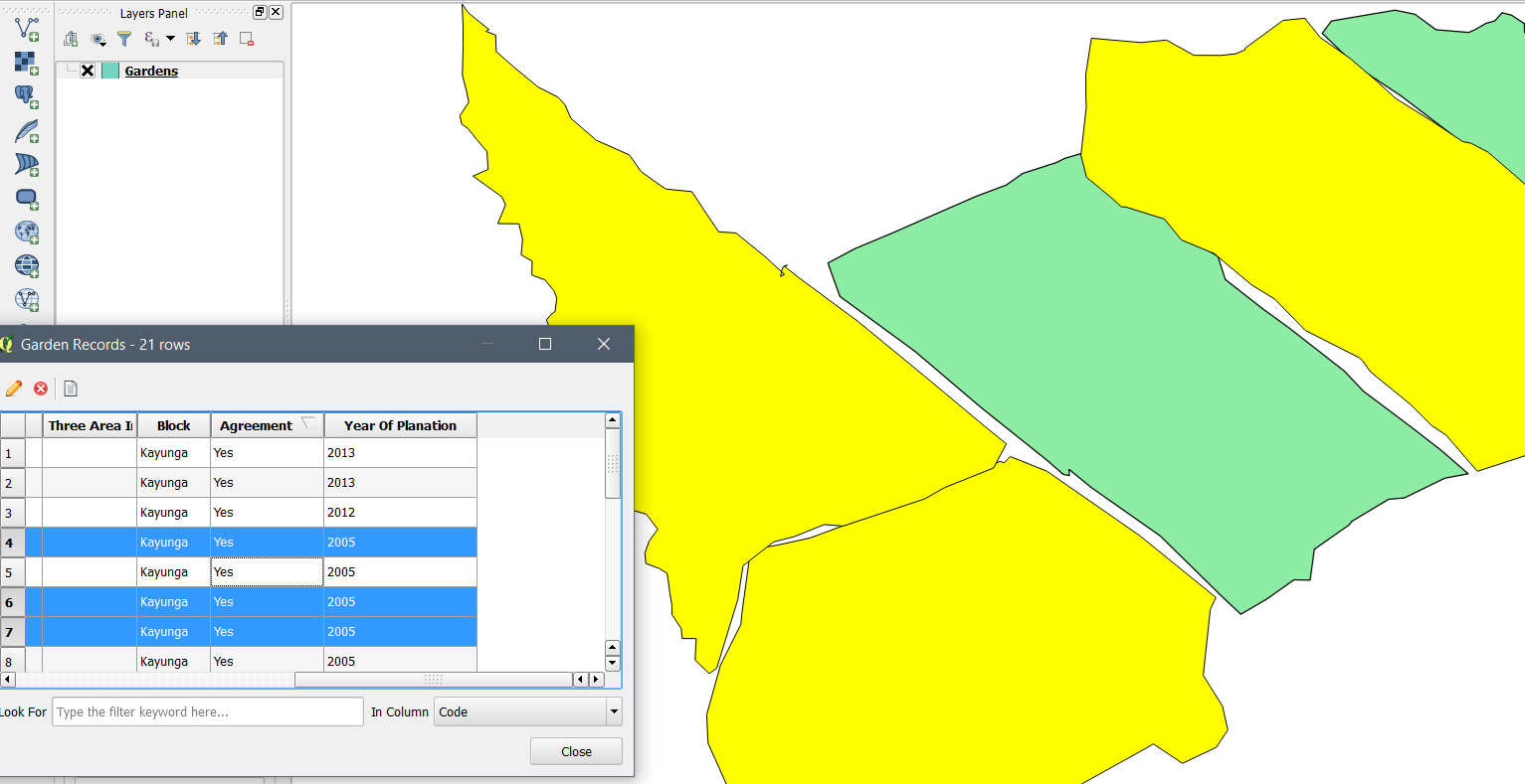
Multi-Selection of Records and Features
The Spatial Entity Browser can now select multiple features in the map canvas when multiple records are selected in the Entity Browser table as shown below.
Ability to Control Map While Browsing Records
The Spatial Entity Browser does not block the clicking of other STDM and QGIS user interface elements. This change enables the user to add a layer, pan the in the map canvas, etc.
View Social Tenure Relationship of the Selected Record
Users can see the social tenure relationship details (via the Spatial Entity Details) of a selected record in the Spatial Entity Browser as shown in the image below.
Documents Designer
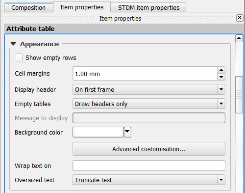
The attribute table composer item used by the Documents Designer has been updated to the latest version of QGIS attribute table item. This upgrade has enabled Item properties panel of the STDM attribute table to add useful option under the Appearance options such as adding empty rows, hiding/showing header, wrapping text, and other customization options as shown below.
Options
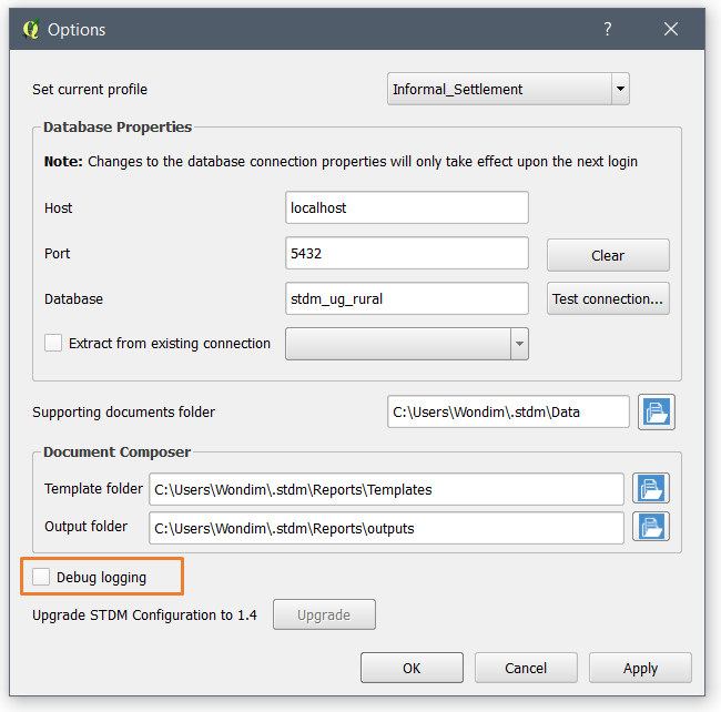
A check box to enable or disable debug mode has been added in the Options module as highlighted in the image below.
General
Software Packages
The all-in-one installer for STDM 1.5 is built upon the following packages: PostgreSQL v9.5, PostGIS 2.2 and QGIS 2.18. STDM is also compatible with QGIS 2.14 and 2.16. See the links below for the full list of feature updates.
Enabling PostGIS Extension
When users create the STDM database manually, there is no need of also creating the PostGIS extension as far as the PostGIS extension is installed for the current PostgreSQL version. This is because, STDM enables the PostGIS extension automatically, if it is not enabled for the database. This will greatly reduce the error that happens due to missing PostGIS extension in the STDM database.